Updating Magnetic Declination in MSFS-2020
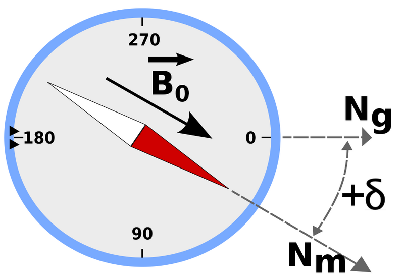
/© odder, Magnetic declination 2, CC BY-SA 3.0
Sometimes, the aircraft during an approach does not correctly align with the runway heading published on the approach chart. This can lead to a RW/APP CRS Error to be displayed on the FMA.
Before exploring scenery, navigational database and add-on inconsistencies, the problem may be that the magnetic declination in flight simulator is not correct for the runway or scenery being used.
The magnetic declination forms part of the database table that relates to any scenery (and airport runway) used in flight simulator.
I have written about magnetic declination in two earlier articles, however, these articles related to FS9 and FSX and not MSFS-2020.
Magnetic Declination
Simply explained, magnetic north is the direction that the north end of a compass needle points, which corresponds to the direction of the Earth's magnetic field. True north is the direction along a meridian towards the geographic North Pole. The magnetic declination (also called magnetic variation) is the angle measured between true north and magnetic north. This distance changes annually and is one of the reasons that a topographic map has a declination table printed in the margin. Without a declination table, the map would soon become inaccurate. To calculate the magnetic declination the map user, depending upon their position, would add or subtract the declination from the bearing to obtain an accurate bearing to plot a course.
Flight Simulator
The magnetic declination used by flight simulator is stored in a .bgl file named magdec.bgl. This file is usually located in the simulator’s scenery database. The file is accurate at the time of development, but if not updated regularly will be incorrect for today’s date.
You would expect magnetic declination errors with flight simulator platforms such as FS9, FSX and earlier versions of P3d; after all, they were released several years ago, but deviation errors are also seen in MSFS-2020. The reason for this is that Microsoft did not compile a new magnetic declination table when the scenery was developed; rather, they used the existing table from FSX. The exception being for some of Asobo’s airports which probably do have up-to-date declination.
Considering that MSFS-2020 is automatically updated, it would have been a relatively easy task to also update the magnetic declination (perhaps in the future).
Updating Magnetic Declination
Updating the declination for MSFS-2020 involves replacing the magdec.bgl file with an updated file.
This file can be downloaded free of charge from Herve Sor’s website (the .bgl file is regularly rewritten to reflect declination changes). Be sure to read the accompanying Read Me file for further information.
Locating the .bgl file (MSFS-2020)
The magdec.bgl file is located in the following directory:
C:\Users\LOGINNAME\AppData\Local\Packages\Microsoft.FlightSimulator_8wekyb3d8bbwe\ LocalCache\Packages\Official\OneStore\FS-base\Scenery\Base\Scenery
Note that if you have done a custom install of MSFS-2020 to a different drive, then the folder structure should represent the location you have installed the software.
If using Steam, the folder structure is:
C:\Steam\Steamapps\Common\MicrosoftFlightSimulator\Official\OneStore\fs-base\Scenery\Base\Scenery\
Installing the .bgl file
Find and open the scenery folder. Prior to changing anything, always make a backup of the existing magdec.bgl file. Be sure to remove the .bgl file extension. I would suggest renaming the file to magdec_backup_original. This enables you, if necessary, to easily roll back the file (after changing the file name back to the original name). The backup file can either remain in the folder or be removed to another location for safe keeping. Next, copy and paste the new magdec.bgl file to the folder. When you open flight simulator the magnetic declination table will be rebuilt during the start-up process. This may take a few minutes.
Important Point:
After downloading the zip file from Herve’s website, open and read the Read Me file which provides additional information.
Other Simulator Platforms
To update the magnetic declination for other simulation platforms, ensure you download the correct updated magdec.bgl file for the simulator being used. The installation route is usually the Scenery/Base/Scenery folder.
Magnetic declination is important. The declination information for the approach chart and the simulator must be identical (Aero Icarus from Zürich, Switzerland, Runway of Funchal airport, July 11, 2011 (5939970718), CC BY-SA 2.0)
Do I Need To Update ?
The flight simulator can only reproduce accurate navigation based on the quality of the installed database. If you are using Navigraph data and your simulator’s declination is not correct, a corresponding error will occur between Navigraph and the scenery in the simulator.
If you use an approach chart, the magnetic declination record between the chart and the simulator must be identical; otherwise, the approach course will be inaccurate (landing left or right of runway). Likewise, if you are using Lateral and Vertical Navigation (LNAV and VNAV) and have the incorrect declination, the aircraft will not fly the correct course during an automated approach (for example an RNAV approach).
The update is a very simple process and takes but a few minutes and it is strongly recommended.
Final Call
Magnetic declination is a critical factor to consider, before investigating other potential causes for navigational discrepancies. To ensure accurate navigation ensure the magdec.bgl file is up-to-date.
Glossary
FMA - Flight Mode Annunciator.


